|
Updated: @
25-Apr-2024 11:49am - next update at 11:50am
|
| Summary / Temperature |
Wind |
Rain |
Outlook |

|
Day time
|

|
64.1°F

---
Feels like:
64°F
24-hr difference
0.6°F |
| |
Today |
Yesterday |
| High: |
64.1°F
11:47am
|
72.9°F
3:34pm |
| Low: |
37.2°F
6:21am
|
38.1°F
5:12am |
|
|


|
SE
2.2
Gust:
1 mph
|
|
1 Bft -
Light Air
|
|
Today:
6 mph
9:54am
|
|
Gust Month: 23.0 mph
April 12
|
|
| Rain Today: |
0 in
|
| Rain Rate (/hr): |
0 in
|
| Rain Yesterday: |
0 in
|
| Storm Rain: |
0 in |
| This Month: |
3.73 in
|
| Season Total: |
11.4 in
|
|
8 rain days in April. |
|
Tonight

Rain
|
|
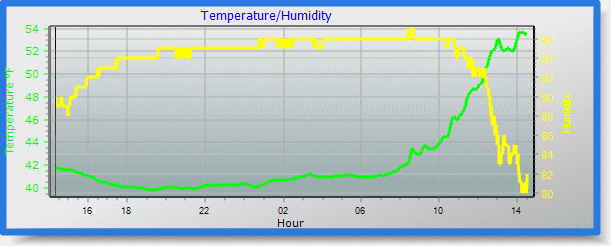
| Humidity & Barometer |
Almanac |
Moon |
| Humidity: |
34 %
 |
| Dew Point: |
35.1°F
|
| Barometer: |
29.836 inHg
|
| Baro Trend: |
Falling slowly
|
|
| Sunrise: |
5:38am |
| Sunset: |
7:44pm |
| Moonset: |
6:08am |
| Moonrise: |
9:06pm |
|
|
Waning Gibbous |

|
97%
Illuminated |
|
| UV Index Forecast |
UV Index Forecast |
|
|
|
 Kamiah Weather